Using Census Tracts to Calculate Population Densities that Matter to Logistics
Serving the U.S. population through a fulfillment network requires awareness about local population densities. What level of local is local enough? For instance, can you just run with population densities for individual U.S. counties?
Our answer — naturally — is: no. You need to assess population densities with more granularity than county boundaries allow for. Fortunately, there’s a cost-efficient method to get there.
You can increase the resolution of population densities by dividing U.S. counties into census tracts. Afterwards, you can apply the arithmetic behind the “80/20” principle and assess what level of local you’ve drilled down to.
A Note on Census Tracts
The U.S. Census establishes tracts as “stable sets of geographic units for the presentation of statistical data.” Granted, the U.S. Census does make adjustments to tracts between each Census.
The U.S. Census tries to limit the population of tracts to between 1,200 and 8,000. The Census does not limit the area of tracts. Hence, tracts vary more in size than population.
There are more advanced methods than drilling down to census tracts to calculate population density. The resolution of those more advanced methods, however, should always be graded against the resolution that census tracts provide.
Hillsborough County, Florida: County Boundaries to Census Tracts
We’re using Hillsborough County, Florida, as an example. For convenience, we refer to population density as: population per square mile.
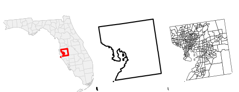
In the 2020 Census, Hillsborough County had a population of 1.45M and a population per square mile of 1,350. In Figure 1, you see Hillsborough County positioned within Florida, with only its county boundary, and then split into census tracts.
The 80/20 Rule Applied to Spatial Data
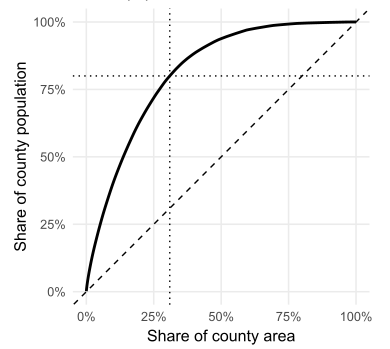
We applied the 80/20 rule to the census tracts of Hillsborough County, Florida. In the 2020 Census, did 80% of Hillsborough County’s population occupy only 20% of the area? Not quite: 80% of the population covered 31% of the area.
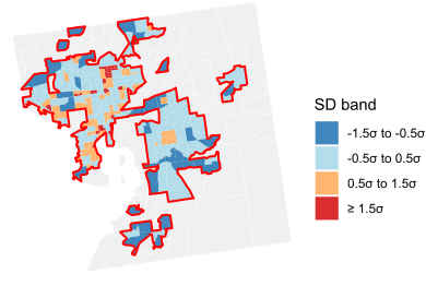
Here’s that 80/31 distribution laid out spatially. For census tracts included in the 31% of the total area, we also present the z-score of population density within Hillsborough County. Is the variance among census tracts’ population density enough to affect operations? That’s a judgement call.